Lady Rita
The rains a'coming
Blowing west, it's a'coming
How come no one knows
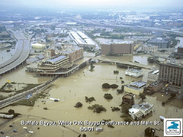
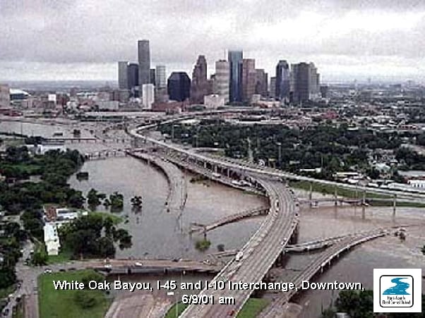
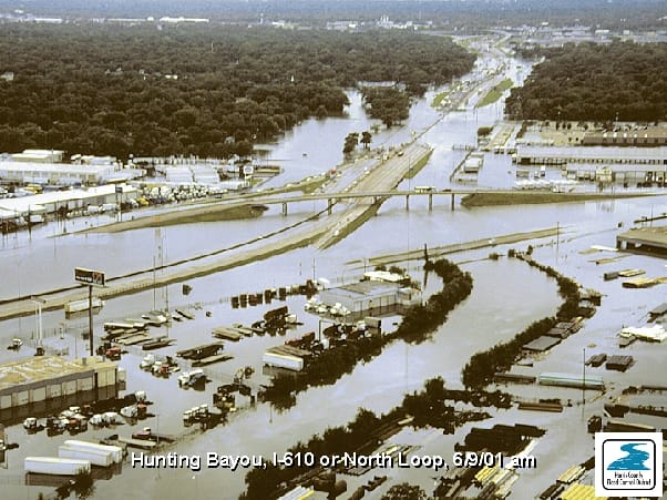
Update: So the parents are staying put. Great great great. God I hope they come to their senses. Here's what a Cat 3 Hurricane did to Houston.
Update: FUCK. It's a category 5 storm now and there are mandatory evacuations for parts of the city. And when I try calling Candice or Mom and Dad, I get "all circuits are busy now, please try again later." FUCK FUCK.
I'm deathly worried for Candice and Mom and Dad in Houston. The eye is expected to make landfall some time late this week, and reports are showing that the Category 4 is going to get only stronger as it churns through the Gulf. I don't know if my house is going to be able to take it. I've been checking national tracking reports and Harris County flood plans and everything I can find in the last 24 hours. This looks like it's going to be a scary scary storm. The last time a Cat 3 hurricane hit Houston was in 1983 – two years before my family settled there. I've implored with Mom and Dad to evacuate, but stubbornly, they're stocking up on essential supplies and are riding it out.
Worst Case Scenario for Houston
- Houston's perfect storm would feed on late summer's warm waters as it barreled northward across the Gulf of Mexico, slamming into the coast near Freeport.
- A landfall here would allow its powerful upper-right quadrant, where the waves move in the same direction as the storm, to overflow Galveston Bay. Within an hour or two, a storm surge, topping out at 20 feet or more, would flood the homes of 600,000 people in Harris County. The surge also would block the natural drainage of flooded inland bayous and streams for a day or more.
- Anything not tied down, from trees to mobile homes to light poles, would become missiles, surreally tumbling and flying through the air, flattening small houses, shattering skyscraper windows and puncturing roofs.
- With sustained winds between 131 mph and 155 mph, the power of a Category 4 storm exceeds that of most building codes.
- "You'll definitely see more significant damage in residential construction," he said. "Lower-end homes, or some homes in older areas, would probably be completely destroyed."
- More devastation would be caused by winds blowing over the Gulf of Mexico and pushing surface water inland -- creating up to a 20-foot storm surge. Such a wall of water would swamp most development near Galveston Bay, including Texas City, Kemah and Johnson Space Center. Varying levels of water would flood much of the area between Sam Houston Parkway and the bay.
- Much like a river becomes deeper and more turbulent when it narrows, a storm surge also can increase in height and intensity when its source of water narrows. Dodson said this has profound implications for the Port of Houston. Some models ended with a 30-foot wall of water in the Ship Channel near the port's turning basin, he said. "It would be huge," he said. "It could overwhelm chemical storage facilities, water treatment plants and other sensitive areas."
- Engineers and forecasters say the most unpredictable element of a storm comes after landfall, when it either dumps rain and floods creeks and bayous or moves quickly enough that relatively little rain falls.
- The last major hurricane most Houston residents remember was Alicia, which made landfall on the west end of Galveston Island in August 1983.
- "Alicia was a marginal Category 3," Dodson said. "Its rainfall doesn't come close to this area's top 20 historical floods.